Coming from the remote sensing world, your day revolves around processing datasets from raster to vector and back. Grab a stereo satellite image of Melbourne, trawl through all the buildings in Leica Stereo view and digitize ground footprint, save to shapefile/kml/whatever vector format is the flavour of the day, render back to raster in 2.5D/3D. There is always information between the cracks of every pixel and delineated polygons and lines that is important but gets mangled in the constant transformation.
Spending some time in the NetCDF world I have become aware of the variety in scientific data and how the rigid Raster/Vector mentality of the GIS world does not really fit with it. Last year I went to the ARSPC Conference in Alice Springs and a Chris Tweedie (Technical Sales from Erdas) gave a talk on the joys of JPEG2000 and how all sorts of data can be stored in this format. There was somebody in the back of the room form IMOS/TERN projects disapproving at the disparity between the expectation of the GIS world and the scientific datasets he is used to hosting.

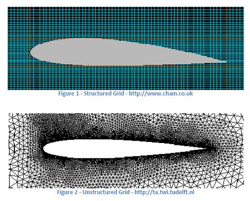
NetCDF has nice and fast access to gridded data sets with co-ordinate conventions allowing storage of data not only using cartesian grids but also with curvilinear grids as long as the parameters producing the grid are properly defined. Now there is move towards making this rather rasterlike approach more vectorlike with the idea of unstructured grids. Then NetCDF will become an even more general (and more complex) representation of all possible data - raster, vectors and everything in-between. There is real need for generalised (non vector/raster) representation of geographic information. Something that emphasizes on utility rather than conformance. The software to handle this data and ultimately the memory models need to think differently (in parallel) to stay in touch with reality. It does not help at all when there is a nomenclature clash, vector mean winds and currents in CMAR and mean points and polygons in GIS.
That aside recently I have spent a fair bit of time migrating from SVN to Mercurial. The OTB project made me fall in love with Mercurial. Afterwards Google code has fostered the obsession with working offline while making commits - aeroplane mode. There are myriads of ways for migrating from SVN to Hg - the stock convert extension, hgsvn or hgsubversion. You can even stay attached to your beloved subversion using subrepository techniques. Not everything however is smooth and some strange empty merging takes place along the way due to the repeated rebasing needed to stay in sync with SVN, hopefully the limbo will be over soon.
Spending some time in the NetCDF world I have become aware of the variety in scientific data and how the rigid Raster/Vector mentality of the GIS world does not really fit with it. Last year I went to the ARSPC Conference in Alice Springs and a Chris Tweedie (Technical Sales from Erdas) gave a talk on the joys of JPEG2000 and how all sorts of data can be stored in this format. There was somebody in the back of the room form IMOS/TERN projects disapproving at the disparity between the expectation of the GIS world and the scientific datasets he is used to hosting.

NetCDF has nice and fast access to gridded data sets with co-ordinate conventions allowing storage of data not only using cartesian grids but also with curvilinear grids as long as the parameters producing the grid are properly defined. Now there is move towards making this rather rasterlike approach more vectorlike with the idea of unstructured grids. Then NetCDF will become an even more general (and more complex) representation of all possible data - raster, vectors and everything in-between. There is real need for generalised (non vector/raster) representation of geographic information. Something that emphasizes on utility rather than conformance. The software to handle this data and ultimately the memory models need to think differently (in parallel) to stay in touch with reality. It does not help at all when there is a nomenclature clash, vector mean winds and currents in CMAR and mean points and polygons in GIS.
That aside recently I have spent a fair bit of time migrating from SVN to Mercurial. The OTB project made me fall in love with Mercurial. Afterwards Google code has fostered the obsession with working offline while making commits - aeroplane mode. There are myriads of ways for migrating from SVN to Hg - the stock convert extension, hgsvn or hgsubversion. You can even stay attached to your beloved subversion using subrepository techniques. Not everything however is smooth and some strange empty merging takes place along the way due to the repeated rebasing needed to stay in sync with SVN, hopefully the limbo will be over soon.
No comments:
Post a Comment