
The talks today started off with a review of XML and why it is not the solve all. The second talk explored the REST idiom for web services. There were a couple of talks about IMOS and TERN indexing disparate NetCDF and HDF data and allowing exploration + download of it via a portal. The inevitable scalability question came up and was left as the elephant in the room. A very detailed talk about Oracle databases and optimizations was an eye opener for me - somebody used to the relatively "just should work" world and PostgreSQL. The last talk felt like a major reimplementation of Google Docs in a semantic space, to easily digest arbitrary data from spreadsheets - the goal is lofty but the proof is in the pudding.
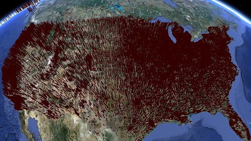
We tried to muster up some support for a visualization platform around NASA WorldWind for community wide acceptance and there was interest from a couple of people. After dinner the talk around visualisation reduced to (or built up to depending on how you look at it) rendering uncertainity both in observations and model output data. Making graphs with regression for my thesis, this has been a common request from my supervisor, I respond to it with error bars and regression confidence interval curves. How does this propagate to a resonable metaphor in worldwind without making every icon hairy with error-bars ? The kml support in WorldWind seems to have also encouraged people to test what can be best described as Google Earth compatibility, leading to these hairy images.

No comments:
Post a Comment