It took a lot of messing around and changing flights to get there but thanks to the excellent folk at Flight Centre Melbourne Airport I arrived on time , left Melbourne 25th July Morning 10:30am and arrived in Vancouver 25th July 7:30am. Again proving the fact that a teleporter is indeed equivalent to a time machine.

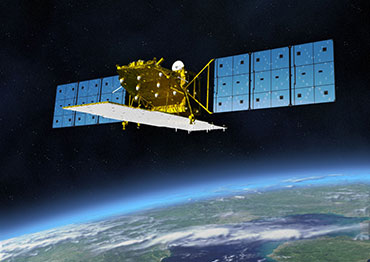
This monday turned out to be full-on 48hour monday, lots of interesting sessions to go to. I attended the plenary by Shimada San introducing ALOS-2 and ALOS-3 with next generations of the great optical and SAR sensors we have come to expect from the Japanese. May be I can sneak into the CALVAL stage and score another trip to Japan.

More flight dramas continued in the background, the presentations blurred into a constant stream of words and diagrams on my sketchbook in the foreground. I learnt a lot about what has been done in the past year and what is coming over the horizon.
I saw science solving political problems with cross-boundary river basin monitoring with Poseidon, Jason-1 and in the future Jason-2. Important basins across unfriendly countries such as Indus, Ganges, Brahmaputra and the Mekong can be monitored by the international science community and appropriate alerts sent and action taken when one of the partner nations or the weather in the river basin begins to misbehave.
I saw the cold-gas (NO2) driven engines that keep TerraSAR-X and Tandem-X locked in their helical dance, not forever, only till the global elevation model project is complete or the gas runs out - whichever comes first. Some extra effort will be required to collect the elevation model of Antarctica, since the satellites will need to be rolled to face left. This is where the polar observation satellites - Cryosat-2 and more, will make a great impact.
I used the conference services a fair bit as well and got labelled "the troublemaker" - thanks people. If you want to get in touch with me just search for the troublemaker at IGARSS.

The real highlights of the week however were the impromptu dinner get-togethers. After the poster session on Monday I drifted off with SAR people from Spain and a few other places. Tuesday night was spent with the OTB team and a fun Columbian guy from ITC. Scientists on one night, engineers on another, we discussed the transition from Science to Engineering to Products, and the effort and mindsets it takes to go the next step, and how the last step provides continuing fuel for the first. The next night it was back to science setting up a collaboration aimed at just such a transition for the OTB ESA Summer of Code in Space (ESA SOCIS 2011). Thursday evening I had great stroll through the Sun Yat Sen garden, dinner at Shukaku and a movie at the Scotiabank Theatre - ultimate self indulgence. Friday, went to very few sessions and spent most of the time in Stanley park sketching totem poles, before catching a flight out. Thank you for a great time Vancouver - I will definitely be back.
This monday turned out to be full-on 48hour monday, lots of interesting sessions to go to. I attended the plenary by Shimada San introducing ALOS-2 and ALOS-3 with next generations of the great optical and SAR sensors we have come to expect from the Japanese. May be I can sneak into the CALVAL stage and score another trip to Japan.
More flight dramas continued in the background, the presentations blurred into a constant stream of words and diagrams on my sketchbook in the foreground. I learnt a lot about what has been done in the past year and what is coming over the horizon.
I saw science solving political problems with cross-boundary river basin monitoring with Poseidon, Jason-1 and in the future Jason-2. Important basins across unfriendly countries such as Indus, Ganges, Brahmaputra and the Mekong can be monitored by the international science community and appropriate alerts sent and action taken when one of the partner nations or the weather in the river basin begins to misbehave.
I saw the cold-gas (NO2) driven engines that keep TerraSAR-X and Tandem-X locked in their helical dance, not forever, only till the global elevation model project is complete or the gas runs out - whichever comes first. Some extra effort will be required to collect the elevation model of Antarctica, since the satellites will need to be rolled to face left. This is where the polar observation satellites - Cryosat-2 and more, will make a great impact.
I used the conference services a fair bit as well and got labelled "the troublemaker" - thanks people. If you want to get in touch with me just search for the troublemaker at IGARSS.

The real highlights of the week however were the impromptu dinner get-togethers. After the poster session on Monday I drifted off with SAR people from Spain and a few other places. Tuesday night was spent with the OTB team and a fun Columbian guy from ITC. Scientists on one night, engineers on another, we discussed the transition from Science to Engineering to Products, and the effort and mindsets it takes to go the next step, and how the last step provides continuing fuel for the first. The next night it was back to science setting up a collaboration aimed at just such a transition for the OTB ESA Summer of Code in Space (ESA SOCIS 2011). Thursday evening I had great stroll through the Sun Yat Sen garden, dinner at Shukaku and a movie at the Scotiabank Theatre - ultimate self indulgence. Friday, went to very few sessions and spent most of the time in Stanley park sketching totem poles, before catching a flight out. Thank you for a great time Vancouver - I will definitely be back.