Monday, August 15, 2011

Sketching paintings and taking photos of sketches - metaart

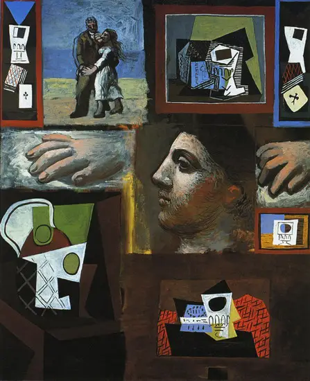
Lately I have been hopping around the world sketching a lot of things I see. I only got told off, actually mildly reprimanded for doing so yesterday at the Henry Jones art hotel. I have been practicing what I can best describe as meta-art or referential art (without repeating all of the title of this post), like this Picasso piece titled etudes. The work at the art hotel is on display for sale purposes and sketching them steals their soul and reduces value.


At least MONA does not suffer from such constraints and I happily reproduced different views of the fat car, plastic enhanced Porsche in pencil, together with glimpses of the surrounding material and carbon-dioxide sensors.

On the ferry back I ran into some very nosy Hobartian who have been snooping on our conversations at Dr. Coffee, but such are the charms of a small town. Now I know who to watch out for when expounding on the joys of Navier-Stokes.

Saturday, August 13, 2011

Confessions of a Google Tourist ( via Stan)

On Wednesday last week I managed to visit Emmanuel and get a guided tour of Googleplex. Patrick dropped me off and asked him to take good care of me. I got free lunch and free dinner - I consider that very good care.

Google is all about software engineering and scalability, now with G+ they are getting into some social engineering as well. As a contribution from the society of people priviledged to visit Google and if you use it file a bug/feature request mentality I get from open source, I started filing thing straight away:
  1. The visitor registration screen asked if you were from Sudan(s), since sometime last month there is no more Sudan. The registration text needed updating.
  2. The glass elevator needs to have the ability to play through time, so that I can show the Southern Surveyor arriving and leaving the docks outside work and the snow levels shifting on Mt. Wellington. I would also like it to have a roof and a floor (whatnick pavement view to be released soon) and seamlessly transition into streetview.
We then drifted off into philosophical discussions about software and refactoring being somewhat similar to Mandala's. Make it - learn about it - throw it away - do it again. The stroll down from Googleplex to the Mountain View Wetlands is great for taking in the squirrels and owls along with other wetland birds.
Here is what we are sending you from YVR @melaneum on Twitpic

After the walk, we finished off the evening with stacks of crepe and conversation. The little boy seems to like the "Sterling Dervish" from Forkometry which is a good sign.

Monday, August 8, 2011

Life and Times of a NASA International Visitor

Monday, 1st of August 2011, I officially signed in as a NASA visitor. Patrick gave me a grand tour of the place. Since photography would get us into trouble in most of the places I resorted to sketching things up. First stop was the Vertical Motion Simulator, which was simulating a VTOL aircraft (tilt-rotor) when we got there. We saw Hangar one (big blimp hangar), the uber Wind tunnel with hockey playing equipment strewn in front of it. We then discussed the past, present and future of WorldWind, Globe viewing client, scalable + distributed data serving, porting to Android platforms and much much more. We finally had a small timeslot to catch up with Mars Rover software team, heavy users of the Ardor3D Java based game engine. I have been building OSGi manifests into Ardor3D and I was preaching the use of the manifest enabled jars in their projects - Antares and Verve. I also discussed the differences between Clipmapped terrain (as in Ardor3d) and Chunked LOD (as in WorldWind) with Leslie and how we can merge the 2 techniques for large terrain rendering to make something scalable, accurate and aesthetically pleasing.
Day two I sat in on one of the WorldWind team telecons and got wind of the developments on Android and challenges of a multitouch interface user semantics, as well as scalability required to proxy and deploy Microsoft Virtual Earth datasets.
On Friday I had a joint showing with Bruce from Emxsys and caught up with Vince Ambrosia and team from the WRAP project. We discussed coupled fire models (terrain + fuel + wind + fire) and UAV derived information assimilation for training and operational fire fighting purposes. Another show-n-tell in NASA hangars followed (including ogling at Google Jets parked in there). We saw the mostly moulded carbon fibre hull SIERRA and discussed air-space management during fires to allow use of UAV's.

Over all it was a highly enlightening trip. One I would like to repeat as soon as possible.

Tuesday, August 2, 2011

Bumping into people in Mountain View - Part 1

The last few days in Mountain View have been full of chance encounters. I better jot them down before they fade from memory. I walked into the US, literally, at Vancouver airport. The passport got stamped by US Customs and bits of Vancouver airport are technically US territory.

On the flight I sat next to a lady (librarian) with sons in Stanford and Twitter. Interesting discussions ensued regarding DNA untwisting and social sensing via Twitter. I caught a cab-ride from SFO to my hotel in Mountain View and promptly fell asleep.

Saturday I visited the NASA AMES' open to public show case and drowned in a sea of high-schoolers visiting under the SMASH umbrella. I listened to a bit of a talk on SOFIA - air-borne telescope. I piped up about seeing infrared with mobile phones and open source at NASA (in response to a student question). This earned me a new label - "mysterious stranger".

I strolled down Moffett Blvd towards Castro hunting for some dinner. A couple rode past on bikes and they were rather offended when I said I didn't know who they were (apparently local TV personalities). I was looking lost at a set of traffic lights and the Mac Outlook lead walked past with his wife and guided me. Some more dining and penciling in what I saw followed.

Sunday I took a trip to the end-of-line in VTA light rail, all the way to Almaden. Then tramped a few more miles to the old Almaden Vineyard site (now a bunch of houses), this was apparently California's first winery. I acquired some charcoal for drawing along the way and made another chance stop at the house of some kids I had met on the train to refill my water bottle. Almaden trip was rounded off by a scramble along the rocky edge of Almaden Lake.

The hopped off the return train to Downtown Mountain View and went into the wine bar at the station. I was trying out my newly acquired charcoal on some wine racks and a chandelier, when an ex-Lockheed employee walked in and talked about his work on the batteries on the Hubble space telescope. So a rendition of Hubble and his name got attached to couple of pages filled with wine racks.

On Monday I visited Patrick and couple of people from the Mars Rover team at NASA, but that is another post. No chance encounter took place.

Sunday, July 31, 2011

IGARSS 2011 Vancouver - Redux (So that you don't fall asleep)

It took a lot of messing around and changing flights to get there but thanks to the excellent folk at Flight Centre Melbourne Airport I arrived on time , left Melbourne 25th July Morning 10:30am and arrived in Vancouver 25th July 7:30am. Again proving the fact that a teleporter is indeed equivalent to a time machine.

Screen shot 2011-07-31 at 6.03.47 PM

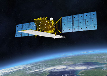
This monday turned out to be full-on 48hour monday, lots of interesting sessions to go to. I attended the plenary by Shimada San introducing ALOS-2 and ALOS-3 with next generations of the great optical and SAR sensors we have come to expect from the Japanese. May be I can sneak into the CALVAL stage and score another trip to Japan.


More flight dramas continued in the background, the presentations blurred into a constant stream of words and diagrams on my sketchbook in the foreground. I learnt a lot about what has been done in the past year and what is coming over the horizon.

I saw science solving political problems with cross-boundary river basin monitoring with Poseidon, Jason-1 and in the future Jason-2. Important basins across unfriendly countries such as Indus, Ganges, Brahmaputra and the Mekong can be monitored by the international science community and appropriate alerts sent and action taken when one of the partner nations or the weather in the river basin begins to misbehave.

I saw the cold-gas (NO2) driven engines that keep TerraSAR-X and Tandem-X locked in their helical dance, not forever, only till the global elevation model project is complete or the gas runs out - whichever comes first. Some extra effort will be required to collect the elevation model of Antarctica, since the satellites will need to be rolled to face left. This is where the polar observation satellites - Cryosat-2 and more, will make a great impact.

I used the conference services a fair bit as well and got labelled "the troublemaker" - thanks people. If you want to get in touch with me just search for the troublemaker at IGARSS.

The real highlights of the week however were the impromptu dinner get-togethers. After the poster session on Monday I drifted off with SAR people from Spain and a few other places. Tuesday night was spent with the OTB team and a fun Columbian guy from ITC. Scientists on one night, engineers on another, we discussed the transition from Science to Engineering to Products, and the effort and mindsets it takes to go the next step, and how the last step provides continuing fuel for the first. The next night it was back to science setting up a collaboration aimed at just such a transition for the OTB ESA Summer of Code in Space (ESA SOCIS 2011). Thursday evening I had great stroll through the Sun Yat Sen garden, dinner at Shukaku and a movie at the Scotiabank Theatre - ultimate self indulgence. Friday, went to very few sessions and spent most of the time in Stanley park sketching totem poles, before catching a flight out. Thank you for a great time Vancouver - I will definitely be back.

Thursday, July 21, 2011

Getting some fish into WorldWind

Last few days I have gone back to biological data, well animal tracks. CSIRO has put together a very nice oceantracks website using the amazing Indie game engine - Unity 3D (amazing in every way except running on Linux). It runs on Android, so with some effort on GL-ES front it can be made to work on Linux.


Talking about multi-platform game engines the other impressive one is Ardor3D,  not that OGRE or Irrilicht are bad. It is just easier to get going without getting platform specific binaries or needing to set up a large tool-chain. It is also easier to maintain the Java based game engine on top of JOGL and LWJGL instead of maintaining JNI bindings to a C++ engine (especially if your bindings are outside the source tree) . The other large draw from Ardor is the JOGL based rendering which lets us share the GLContext between Ardor and WorldWind, as I have done in jaxb-collada (lots of thanks to the original Ardor hack post and improvements from niccastel and brujito). Some pretty famous use-cases have picked Ardor up as their rendering engine including the Mars rover project, I hope to catch up with them in a few weeks. May be the local guys down here in Hobart will adopt it as a mission control system for the SLOCUM Gliders.


There are some altitude setting bugs in the Ardor3D+WorldWind code , and the animations key-frames are not enabled, but the models load nicely and will look great with some more water surface shaders and actual track data.

WorldWind_Tuna

Friday, July 15, 2011

GSOC 2011 - Sub-surface Features in WorldWind

Honestly I did not sign up to mentor this project, but I kind of drifted into throwing some advice by the way of the student. Doing a prototype of sub-surface visualisation is not at all difficult, but it is difficult to get it right, to convey the information without losing the context provided by the draped textures.

California Seismic or Australia Boreholes data goes down into the earth's crust. The crust is not that thick (only a few 10's of km in the 6000 or so km's of earth radius). Thinks get a bit weird in portraying things accurately while using vertical exaggeration. The surface of the earth becomes a bit of an event horizon. Nevertheless good progress has been made with changing the transparency of the surface textures and deploying secondary meshes below the normal terrain mesh. The aim is to get something close to Rockworks. The implementation so far tweaking secondary meshes in WorldWind can be seen here: